Last Updated: December 22, 2025
When Queen Victoria chose a remote lumber town as Canada’s capital in 1857, politicians across the colonies were stunned—but her controversial decision would prove to be one of the most strategically brilliant choices in Canadian history.
The story of how Ottawa became Canada’s capital reads like an underdog tale. In the 1850s, Ottawa—then known as Bytown—was considered a rough-edged frontier town dominated by rowdy lumberjacks, far removed from the sophisticated cities of Montreal, Toronto, and Quebec City. Yet this unlikely candidate would be selected over its prestigious rivals to become the seat of government for a new nation. The transformation from a military construction camp to the political heart of Canada is a fascinating journey through ambition, engineering marvels, political compromise, and strategic foresight.
Key Highlights
TL;DR: Ottawa began as Bytown in 1826 during Rideau Canal construction, was renamed in 1855, and became Canada’s capital in 1857 when Queen Victoria chose it over Montreal, Toronto, Kingston, and Quebec City due to its strategic location between English and French Canada and its defensible position.
| Quick Facts | Details |
|---|---|
| 📅 Founded as Bytown | 1826 (during Rideau Canal construction) |
| 📅 Renamed Ottawa | January 1, 1855 |
| 📅 Chosen as Capital | December 31, 1857 (by Queen Victoria) |
| 📍 Strategic Location | Border of Upper and Lower Canada |
| 🏛️ Parliament Buildings Completed | 1866 (Centre Block) |
Before Bytown: Indigenous Peoples and the Land
Long before European settlers arrived, the Ottawa River valley was home to the Algonquin Anishinaabe peoples, who had inhabited these lands for thousands of years. The river itself—originally called Kitchissippi (meaning “Great River” in Algonquin)—served as a vital transportation corridor and trading route connecting the Great Lakes to the St. Lawrence River.
The Algonquin people used the Chaudière Falls, where the Ottawa River narrows dramatically, as a gathering place for trade, ceremony, and sustenance. They navigated the challenging rapids with expertise, portaging their canoes around the most dangerous stretches. The abundance of fish, game, and waterways made this region ideal for settlement.
When French explorers arrived in the early 1600s, they adopted Indigenous place names and relied on Algonquin guides to navigate the complex river systems. Samuel de Champlain travelled up the Ottawa River in 1613 and 1615, documenting the falls and rapids that would later become central to Bytown’s development. For two centuries, the area remained primarily Indigenous territory with scattered fur trading posts, until military necessity brought dramatic change.
The Rideau Canal and Birth of Bytown (1826)
The War of 1812 exposed a critical vulnerability in British North America’s defenses. The St. Lawrence River route between Montreal and Kingston lay dangerously close to the American border, making it susceptible to attack. British military strategists needed an alternative supply route that could safely transport troops and materials between the St. Lawrence and Lake Ontario—one that ran entirely through British territory.
The solution was the Rideau Canal, an ambitious engineering project that would connect the Ottawa River to Lake Ontario via the Rideau River system. In 1826, Lieutenant Colonel John By of the Royal Engineers arrived at the confluence of the Ottawa, Rideau, and Gatineau Rivers with orders to build this 202-kilometre waterway. The location, known as “the Chaudière” for its massive waterfall, would serve as the canal’s northern terminus.
Colonel By established a military construction camp on the south bank of the Ottawa River, and almost immediately, workers, merchants, and entrepreneurs flooded into the area. What started as a temporary camp of tents and rough shanties quickly evolved into a bustling settlement. Workers needed housing, food, supplies, and entertainment—and entrepreneurs were eager to provide all of it.
By 1828, the settlement had grown substantial enough to warrant a name. Residents began calling it “Bytown” in honour of their founder, Colonel John By. The town developed distinct neighbourhoods: Upper Town (now Centretown) housed officers, merchants, and professionals on the elevated ground, while Lower Town (now the ByWard Market area) became home to laborers, tradesmen, and the rougher elements of frontier society.
Colonel John By: The Town’s Founder
Lieutenant Colonel John By was a 46-year-old Royal Engineers officer when he received the commission to build the Rideau Canal. Born in London in 1779, By had distinguished himself during the Napoleonic Wars and earned a reputation as a skilled military engineer. His assignment to British North America would define his legacy, though it would also bring him considerable grief.
Colonel By approached the canal project with ambitious vision and meticulous planning. Unlike other military engineers who might have built a basic supply route, By envisioned a canal capable of handling large steamboats and commercial traffic. He designed massive stone locks—some of the largest in the world at the time—and oversaw construction of defensive structures, mills, and infrastructure.
His engineering decisions shaped Bytown’s early development. By selected the Entrance Valley (where the canal meets the Ottawa River) as the town’s focal point, established the initial street grid, and designated land for military installations, commercial development, and worker housing. He personally surveyed much of the townsite and made decisions about where roads, bridges, and public buildings should be located.
The canal project faced enormous challenges: harsh winters, outbreaks of malaria among workers, difficult terrain, and constant budget overruns. By pushed forward with determination, but the mounting costs—the final price tag reached £822,804, far exceeding initial estimates—created political controversy back in London. When the canal opened in 1832, it was an engineering marvel, but By faced harsh criticism for the expense.
Recalled to London in 1832, Colonel By defended his work before a parliamentary committee but never received the recognition he deserved during his lifetime. He died in 1836, largely forgotten. Only decades later did Canadians fully appreciate his vision and technical genius. Today, his name graces streets, parks, and landmarks throughout Ottawa, and he’s remembered as the city’s founding father.
Early Bytown: A Rough Lumber Town
After the Rideau Canal’s completion in 1832, Bytown faced an identity crisis. Built for a military purpose, the town needed a new economic foundation. The answer came from the vast forests surrounding the Ottawa River valley. Bytown transformed into one of North America’s premier lumber centres, shipping timber down the Ottawa River to Montreal and international markets.
The lumber industry brought prosperity, but it also gave Bytown a rough reputation. Each spring, thousands of Irish and French-Canadian lumberjacks—called “shantymen”—descended from logging camps in the Ottawa Valley and crowded into Lower Town’s taverns, boarding houses, and streets. These men had spent isolated winter months in the bush, and they arrived in Bytown ready to spend their wages on alcohol, entertainment, and settling old grievances.
Sectarian violence between Irish Catholics and French Canadians became common, particularly in the area around Pooley’s Bridge (later renamed Sappers Bridge). The most notorious conflicts were the “Shiners’ Wars” of the 1830s and 1840s, when Irish gangs called “Shiners” battled French-Canadian workers for control of logging territories and jobs. Street brawls, riots, and even murders occurred with disturbing frequency.
Upper Town residents looked down—literally and figuratively—on the chaos in Lower Town. The social and geographic divide between prosperous Upper Town and working-class Lower Town created distinct communities with different cultures, languages, and religions. Upper Town’s merchants, government officials, and professionals maintained Victorian respectability, while Lower Town embraced the frontier’s rougher edges.
Despite its reputation, Bytown grew steadily through the 1840s and early 1850s. The lumber trade brought wealth, attracting banks, shops, hotels, churches, and schools. The Byward Market, established in 1826, became a commercial hub. Stone buildings replaced wooden structures, and civic leaders began envisioning a more refined future for their town.
The Renaming to Ottawa (1855)
By the early 1850s, Bytown’s civic leaders recognized that their town’s name created image problems. “Bytown” sounded provincial and rough—hardly appropriate for a community with ambitions of becoming a major city. The name also carried associations with the town’s rowdy lumber heritage and sectarian violence.
Community leaders proposed adopting “Ottawa,” the name of the river and the Indigenous people who had long inhabited the region. The word “Ottawa” (derived from the Algonquin “Odawa”) meant “traders” and reflected the area’s commercial heritage. It sounded more dignified, more established, and more suitable for a prosperous city.
On January 1, 1855, Bytown officially became Ottawa. The renaming coincided with Ottawa’s incorporation as a city, marking a symbolic fresh start. With a population approaching 10,000, Ottawa had outgrown its frontier origins and aspired to join the ranks of British North America’s major urban centres.
The timing proved fortuitous. Just two years later, Ottawa would need every advantage in competing for the greatest prize in colonial politics: selection as the capital of the United Province of Canada.
Why Queen Victoria Chose Ottawa (1857)
The Capital Question: A Political Nightmare
By the 1850s, the United Province of Canada (formed in 1841 by merging Upper and Lower Canada) faced a seemingly unsolvable problem: where should the capital be located? The question had plagued politicians for years, causing bitter divisions and governmental instability.
The province had tried rotating the capital between Toronto (formerly York) and Quebec City every four years, but this arrangement satisfied no one. Moving the entire government apparatus—legislators, civil servants, records, and equipment—back and forth proved expensive, inefficient, and disruptive. Politicians spent more time arguing about where they should meet than actually governing.
Four cities emerged as serious contenders for permanent capital status, each with passionate supporters and compelling arguments:
Montreal was the largest and wealthiest city, the commercial heart of British North America. It boasted superior infrastructure, cultural institutions, and international connections. However, the 1849 riots—when an English-speaking mob burned down the Parliament buildings to protest the Rebellion Losses Bill—raised serious questions about political stability. Montreal’s overwhelmingly English business elite also made French Canadians suspicious of its selection.
Toronto (renamed from York in 1834) had emerged as Upper Canada’s dominant city, with rapid population growth and economic expansion. Proponents argued Toronto represented the future—progressive, English-speaking, and commercially dynamic. But French Canadians saw Toronto as too distant, too English, and too aligned with Upper Canadian interests that often conflicted with Lower Canada’s needs.
Quebec City carried the weight of history as the oldest European settlement in Canada, with deep roots in French-Canadian culture and tradition. Its selection would honour Lower Canada’s heritage and reassure French Canadians of their place in confederation. However, Quebec City’s location far down the St. Lawrence made it inconvenient for Upper Canada, and English speakers viewed it as too French, too Catholic, and too backward-looking.
Kingston had served briefly as capital from 1841-1844 and maintained strong support, particularly among British military officials who valued its strategic location and fortifications. Situated midway between Toronto and Montreal, Kingston offered geographic compromise. But the city lacked the size, economic strength, and cultural institutions of its larger rivals, and neither English nor French Canadians felt passionate attachment to it.
Politicians deadlocked. Any choice would alienate a major constituency. The Legislative Assembly voted repeatedly on the capital question, with different cities winning narrow majorities at different times. The instability became so severe that the government of John A. Macdonald fell in 1858 partly over the capital controversy.
Passing the Decision to Queen Victoria
In desperation, politicians devised an ingenious solution: let Queen Victoria decide. In 1857, the Legislative Assembly voted to request that Her Majesty select the permanent capital. This strategy offered multiple advantages. It removed the decision from colonial politics, preventing any faction from being blamed. It gave the choice imperial authority that would be difficult to challenge. And it reflected Victorian-era deference to the Crown’s wisdom.
Queen Victoria likely consulted with British colonial officials, military strategists, and Canadian advisors before making her decision. While no detailed record of her deliberations survives, the strategic reasoning behind the choice is clear.
Why Ottawa Won
On December 31, 1857, Queen Victoria announced her decision: Ottawa would be Canada’s capital. The choice shocked many politicians and commentators. Ottawa seemed like the least likely candidate—smaller than the rival cities, lacking their cultural sophistication, still bearing the rough edges of a lumber town.
But Queen Victoria’s choice reflected brilliant strategic thinking:
Geographic Compromise: Ottawa sat on the border between Upper and Lower Canada (Ontario and Quebec), literally bridging the English-French divide. Neither linguistic community could claim it entirely as their own, making it a neutral ground. The Ottawa River itself formed the boundary between the two provinces, with Hull (now Gatineau) on the Quebec side and Ottawa on the Ontario side.
Political Balance: Unlike Toronto, Montreal, or Quebec City—each strongly associated with particular political and cultural factions—Ottawa had no powerful entrenched interests. It was politically “clean,” without the baggage of previous capital controversies or riots.
Defensible Position: British military strategists valued Ottawa’s location far from the American border. After the War of 1812 and amid recurring Anglo-American tensions in the 1850s, keeping the capital at a safe distance from potential invasion made military sense. The Rideau Canal provided a secure supply route to Lake Ontario, and the rugged Canadian Shield landscape north of Ottawa would make any American advance difficult.
Room for Growth: Ottawa had abundant land available for government buildings, expansion, and planned development. Unlike crowded Montreal or Toronto, architects could design a purpose-built capital complex from near scratch.
Existing Infrastructure: Thanks to the Rideau Canal, Ottawa had solid infrastructure—locks, bridges, mills, and transportation links. The canal provided commercial connection to Lake Ontario and the St. Lawrence, while the Ottawa River linked to Montreal and the timber regions.
The decision faced immediate criticism. Toronto and Montreal politicians fumed. Newspapers in the rival cities published scathing editorials calling Ottawa “a sub-arctic lumber village” and questioning the Queen’s judgment. But the choice was made, and its imperial authority made reversal politically impossible.
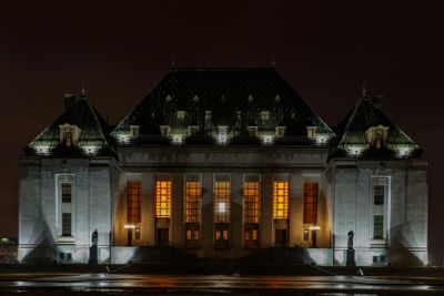
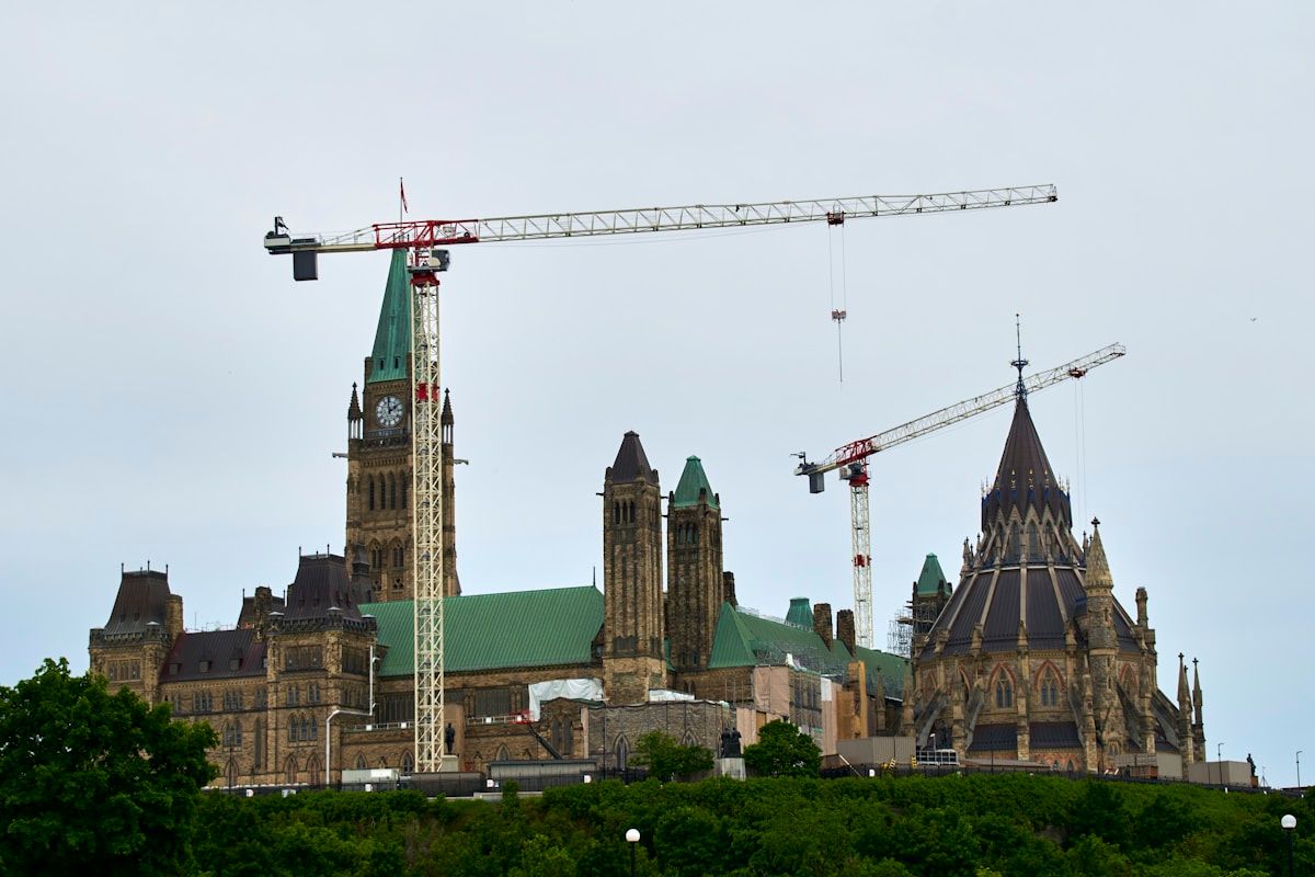
Building Parliament Hill
Queen Victoria’s selection of Ottawa meant the city needed government buildings worthy of a national capital. In 1859, the province launched a design competition for new Parliament Buildings, to be constructed on Barrack Hill—a dramatic limestone bluff overlooking the Ottawa River.
The winning designs reflected the High Victorian Gothic Revival style popular in Britain, chosen deliberately to evoke Westminster and reinforce Ottawa’s connection to the British Empire. Three main buildings would form the parliamentary complex:
The Centre Block would house the legislative chambers, with a soaring Peace Tower (originally the Victoria Tower) as its centerpiece. Architects Thomas Fuller and Chilion Jones designed an imposing structure featuring pointed arches, carved stonework, ornate ironwork, and a copper roof that would oxidize to distinctive green.
The East Block and West Block would contain ministerial offices and support services. These complementary buildings, designed by different architects, shared the Gothic Revival aesthetic while maintaining distinct characters.
Construction began in 1859 and proceeded through the 1860s amid political turmoil, budget concerns, and the broader drama of Canadian Confederation. Workers quarried limestone from local sources, carved intricate details, and assembled one of the most ambitious architectural projects in British North America.
The Centre Block officially opened in 1866, just in time for the final legislative sessions of the United Province of Canada. One year later, in 1867, these same chambers would host the birth of the Dominion of Canada as Confederation united the provinces under a federal government. The new Parliament Buildings provided the stage for this historic transformation.
The buildings’ Gothic grandeur transformed Ottawa’s image. No longer could critics dismiss the capital as a rough lumber town—the Parliament Buildings announced Ottawa’s importance and permanence. They also established architectural patterns that would influence government buildings, churches, and major structures throughout the city.
Ottawa’s Growth as a Capital
Becoming Canada’s capital in 1867 transformed Ottawa from a regional lumber town into a national city. The federal government became Ottawa’s dominant employer, bringing thousands of civil servants, politicians, diplomats, journalists, and support workers. The population surged from about 18,000 in 1861 to over 44,000 by 1881.
Government investment poured into infrastructure. New bridges connected Ottawa to Hull across the Ottawa River. Railway lines linked the capital to Montreal, Toronto, and the expanding national network. Grand hotels like the Russell House accommodated visiting dignitaries and politicians. Government buildings spread beyond Parliament Hill, occupying expanding office spaces throughout the city.
The capital’s status attracted cultural institutions. The Dominion Observatory (1905), National Gallery of Canada (1880), National Museum (1910), and Public Archives (1872) established Ottawa as a centre for science, art, and scholarship. Universities, libraries, and research institutions followed.
Yet Ottawa’s transformation wasn’t without tensions. The lumber industry remained economically vital through the late 19th century, creating an odd juxtaposition: refined politicians and diplomats sharing streets with rough shantymen and mill workers. The class divisions between elite Upper Town and working-class Lower Town persisted, though gradually softened as the city matured.
The city’s bilingual character deepened. Federal government operations required both English and French speakers, attracting francophones from Quebec and acadians from the Maritimes. Hull and other Quebec communities across the river grew rapidly, creating a metropolitan region that straddled provincial and linguistic boundaries.
The Great Fire of 1900
On April 26, 1900, disaster struck Ottawa. A small fire in Hull, likely started by a discarded chimney spark, exploded into a catastrophic conflagration. Driven by high winds and feeding on Hull’s wooden buildings and lumber piles, the fire crossed the Ottawa River and tore through Ottawa’s western neighbourhoods.
The Great Fire of 1900 burned for over 10 hours, destroying seven square kilometres and leaving 15,000 people homeless—roughly one-fifth of the combined Ottawa-Hull population. Entire neighbourhoods vanished. The lumber industry, which had made Ottawa prosperous, provided abundant fuel for the inferno. Seven people died, and property damage reached millions of dollars (astronomical in 1900 currency).
The fire narrowly missed Parliament Hill, though government officials evacuated important documents and prepared for the worst. Had the wind shifted slightly, Canada’s Parliament Buildings might have burned just 33 years after Confederation.
Ottawa rebuilt quickly, but the fire prompted significant changes. Building codes mandated more fire-resistant construction materials. The lumber industry, already declining due to depleted forests and changing economics, never fully recovered—effectively ending Ottawa’s timber era. The disaster accelerated Ottawa’s transformation from lumber town to government city, marking a definitive break with the frontier past.
Ironically, a second major fire struck Parliament Hill’s Centre Block in 1916, destroying most of the building though sparing the Library of Parliament. The current Centre Block and Peace Tower date from the 1916-1927 reconstruction, slightly different from the original Victorian Gothic design.
Modern Ottawa: From Town to City
Through the 20th century, Ottawa evolved from a Victorian-era capital into a modern metropolitan centre. Several key developments shaped this transformation:
The Greber Plan (1950): French urbanist Jacques Gréber designed a comprehensive plan that created parkland along the Ottawa River, established the Greenbelt to control urban sprawl, relocated railway lines, and improved roadways. This visionary planning gave Ottawa its distinctive character—a capital city integrated with natural beauty.
Government Expansion: The federal civil service grew dramatically, particularly during and after World War II. Massive office complexes spread throughout downtown Ottawa and Hull (renamed Gatineau in 2002). Government work provided stable employment and attracted educated professionals from across Canada.
Cultural Development: The National Arts Centre (1969), Canadian Museum of History (1989), Canadian War Museum (2005), and other institutions established Ottawa as a cultural hub. Annual events like Winterlude and the Canadian Tulip Festival (commemorating Dutch gratitude for wartime sanctuary) became national traditions.
Bilingual Capital: The Official Languages Act (1969) reinforced Ottawa-Gatineau’s bilingual character, requiring federal services in both English and French. This policy shaped hiring, education, and daily life, making Ottawa one of North America’s most bilingual cities.
Technology Sector: From the 1970s onward, Ottawa developed a robust technology industry, earning the nickname “Silicon Valley North.” Companies like Nortel, Mitel, Shopify, and numerous tech startups diversified the economy beyond government.
Today, Ottawa is Canada’s fourth-largest city, with a metropolitan population exceeding 1.4 million. It ranks among the world’s most educated cities, with high percentages of residents holding university degrees. The economy balances government, technology, tourism, and services.
Yet Ottawa retains connections to its history. The Rideau Canal—Colonel By’s engineering marvel—became a UNESCO World Heritage Site in 2007. The ByWard Market still thrives on streets laid out in the 1820s. Parliament Hill remains the architectural and symbolic heart of the nation.
Historic Sites You Can Visit Today
Ottawa preserves its remarkable history through numerous sites open to visitors:
Parliament Hill: Tour the Centre Block (reopening after renovations in 2030s), East Block, and West Block. The library of Parliament, which survived the 1916 fire, showcases Victorian Gothic architecture at its finest. Free tours available year-round.
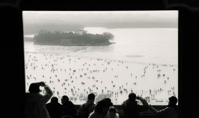
Rideau Canal: Walk, bike, or boat along Colonel By’s masterpiece. In winter, the canal becomes the world’s largest skating rink. The canal’s locks, particularly the eight-lock system at Parliament Hill, operate much as they did in 1832.
Bytown Museum: Located in Ottawa’s oldest stone building (1827), this museum tells the story of Bytown’s founding and early years. The building itself served as the Commissariat during canal construction.
ByWard Market: Established in 1826, this is one of Canada’s oldest continuously operating public markets. The area retains much of its 19th-century street pattern and historic buildings, now housing restaurants, shops, and galleries.
Major’s Hill Park: Named for Major Daniel Bolton, this park offers stunning views of Parliament Hill, the Ottawa River, and Gatineau. It occupies land that once held Colonel By’s residence.
Rideau Hall: The official residence of Canada’s Governor General since 1867, with public tours showcasing Canadian art, architecture, and history.
Canadian Museum of History: Located in Gatineau, this museum explores Canadian history from Indigenous peoples through Confederation to the present day.
Notre-Dame Cathedral Basilica: Ottawa’s oldest and largest church (1846-1885), featuring stunning Gothic Revival architecture and twin spires visible across downtown.
Sussex Drive Heritage Buildings: This historic street features numerous 19th-century buildings, including the former American Embassy and various diplomatic residences.
Laurier House: Former home of two Prime Ministers (Sir Wilfrid Laurier and William Lyon Mackenzie King), preserved as a National Historic Site.
Walking Tours of Historic Ottawa
Several walking routes let you explore Ottawa’s transformation from Bytown to capital:
Parliamentary Precinct Walk (2-3 hours): Start at Parliament Hill, walk through Major’s Hill Park, visit the Bytown Museum, explore the locks, and end at the ByWard Market. This route traces Colonel By’s original town plan and shows how the government district developed.
Sussex Drive Heritage Route (2 hours): Follow Sussex Drive from the National Gallery past Rideau Hall, seeing how Ottawa’s elite residential areas developed in the late 19th century.
Rideau Canal Heritage Walk (3-4 hours): Walk from Parliament Hill locks south along the canal to Dow’s Lake, seeing how the canal shaped Ottawa’s growth and neighbourhood development.
Lower Town Heritage Route (1-2 hours): Explore the ByWard Market area, York Street, and the Lowertown neighbourhood where workers, tradesmen, and immigrants built their community in Bytown’s early decades.
Guided heritage walks operate spring through fall, offered by Heritage Ottawa and other organizations. Self-guided tours with smartphone apps and historical markers let you explore year-round.
FAQ
Q: Why was Bytown renamed Ottawa?
Civic leaders chose “Ottawa” in 1855 to give the city a more dignified identity as it grew beyond its frontier origins. The name honored the Ottawa River and the Indigenous Odawa people, sounding more refined than “Bytown” and shedding associations with the town’s rough lumber heritage and sectarian violence.
Q: Did Queen Victoria ever visit Ottawa?
No, Queen Victoria never visited Canada despite choosing Ottawa as its capital. She made her selection based on strategic advice from military officials and colonial administrators. However, her descendants have visited frequently—nearly every British monarch and royal family member since has toured the capital Victoria selected.
Q: What happened to Colonel John By after building the canal?
Colonel By was recalled to London in 1832 to face parliamentary criticism about the canal’s cost overruns. Though he defended his engineering decisions, he never received recognition during his lifetime and died in obscurity in 1836. Only decades later did Canadians appreciate his vision and honour him as Ottawa’s founder.
Q: How did Ottawa beat Montreal and Toronto for capital status?
Ottawa won because it offered political compromise—sitting on the English-French border, it favored neither linguistic group. Queen Victoria’s military advisors also valued its defensive position far from the American border and its connection to the Rideau Canal supply route. Montreal’s 1849 riots and Toronto’s partisan associations hurt their chances.
Q: Is the Rideau Canal still used for transportation?
The canal no longer serves its original military purpose, but recreational boats use it extensively during navigation season (mid-May to mid-October). Pleasure craft, kayakers, and canoeists travel the 202-kilometre route between Ottawa and Kingston. In winter, the downtown section becomes a world-famous skating rink.
Q: What caused the Great Fire of 1900?
The fire likely started in Hull from a chimney spark landing in dry wood debris. High winds spread the flames rapidly through Hull’s wooden buildings and lumber piles, then carried burning embers across the Ottawa River into Ottawa’s western neighbourhoods. The lumber industry’s presence—stacks of timber and wooden structures—fueled the catastrophe.
Q: When did Ottawa stop being a lumber town?
The transition occurred gradually from the 1860s through early 1900s. Government growth after 1867 diversified the economy, while depleted forests and the 1900 fire weakened the lumber industry. By World War I, government had clearly surpassed lumber as Ottawa’s economic foundation, though some timber operations continued into the mid-20th century.
Q: Can you tour the original Rideau Canal locks?
Yes, the eight original locks at the Ottawa end of the canal still operate using the hand-cranked mechanisms installed in the 1820s-1830s. Parks Canada maintains them as working historical artifacts. Visitors can watch boats being raised or lowered through the locks using 19th-century technology, much as Colonel By designed nearly 200 years ago.
Final Thoughts
Ottawa’s journey from wilderness to Bytown to Canada’s capital represents one of the most unlikely success stories in North American urban history. What started as a military construction camp became a rough lumber town, then transformed into a national capital—all within the span of a single lifetime in the 19th century.
The decision that seemed so controversial in 1857 proved remarkably wise. Queen Victoria’s choice gave Canada a capital that belonged to neither of the country’s founding linguistic communities but to both—a neutral ground where English and French could meet as equals. Ottawa’s geographic position, which seemed disadvantageous to critics who wanted a larger, more established city, turned out to provide exactly the political balance Canada needed as it grew into a bilingual, bicultural nation.
Colonel John By would scarcely recognize the city that bears his name, yet his fundamental contribution—the Rideau Canal and the town plan he surveyed—still shapes Ottawa today. The canal remains both functional and beautiful, a UNESCO World Heritage Site and the heart of the capital’s identity. The street grid he established still defines downtown neighbourhoods.
The transformation continues. Modern Ottawa balances its role as national capital with aspirations as a technology hub, cultural centre, and livable city. The timber rafts and shantymen are long gone, replaced by government workers, tech entrepreneurs, diplomats, and artists. But the spirit of that unlikely choice—the decision to build a capital in an unexpected place—still defines Ottawa’s character: ambitious, resilient, and constantly evolving.
For visitors exploring historic Ottawa today, the past remains remarkably present. You can walk streets Colonel By surveyed, pass through canal locks his engineers built, and stand on Parliament Hill where Queen Victoria’s controversial decision proved its wisdom. From Bytown to Ottawa, from lumber town to capital, the story continues to unfold in one of the world’s most distinctive and successful capital cities.
Source: Library and Archives Canada, Bytown Museum, Parks Canada Rideau Canal National Historic Site, City of Ottawa Archives, Canadian Encyclopedia