Last Updated: December 30, 2025
Ottawa ranks among Canada’s top hiking destinations, with over 165 kilometres of maintained trails in Gatineau Park alone and hundreds more throughout the Greenbelt and surrounding conservation areas. Whether you are seeking a peaceful boardwalk stroll through a 10,000-year-old bog, a challenging escarpment climb with 290 metres of elevation gain, or a family-friendly waterfall adventure, the Ottawa-Gatineau region delivers exceptional outdoor experiences just minutes from downtown.
The capital region’s hiking scene spans two provinces and diverse ecosystems. Gatineau Park, Canada’s second-most-visited federal park after Banff, anchors the region with 361 square kilometres of protected wilderness featuring the dramatic Eardley Escarpment, pristine lakes, and forested ridges. Ottawa’s Greenbelt adds another 20,000 hectares of conservation lands, including the internationally significant Mer Bleue wetland and the Stony Swamp Conservation Area. Further afield, the Canadian Shield terrain around Calabogie and the Madawaska Highlands offers rugged adventure hiking with panoramic lake views.
This guide covers 25 of the best hiking trails near Ottawa for 2026, organized by difficulty level, special features, and distance from the city. Each trail includes exact parking locations, GPS coordinates where available, elevation profiles, seasonal recommendations, and insider tips for the best experience. From the turquoise waters of Pink Lake to the dramatic cliffs of Eagle’s Nest, these trails showcase the diverse natural beauty that makes Ottawa a paradise for outdoor enthusiasts year-round.
Key Highlights
TL;DR: The Ottawa-Gatineau region offers world-class hiking ranging from 1-km wheelchair-accessible boardwalks to 14-km challenging escarpment climbs with 480 metres of elevation gain. Gatineau Park charges $5-15 per vehicle at designated lots (annual passes $90), while most Greenbelt trails offer free parking. Peak fall foliage typically occurs from late September through mid-October, with the escarpment lookouts providing the most dramatic views.
| Quick Facts | Details |
|---|---|
| Total Trails Covered | 25 routes for all skill levels |
| Gatineau Park Trails | Over 165 km of maintained paths across 361 sq km |
| Ottawa Greenbelt Trails | 150+ km of paths through 20,000 hectares |
| Distance from Downtown | 10-120 minutes driving |
| Best Season | May-October (year-round options available) |
| Gatineau Park Parking | $5 (1 hour) to $15 (all day), annual pass $90 |
| Greenbelt Parking | Free at all NCC Greenbelt trailheads |
| Dog-Friendly Options | 15+ trails allow leashed dogs (April-November) |
| Wheelchair Accessible | 5 fully accessible trails with boardwalks |
| Waterfall Trails | 8 trails featuring seasonal or year-round waterfalls |
Understanding the Trail Network
The Ottawa-Gatineau region’s hiking trails fall under three main management systems:
National Capital Commission (NCC) - Gatineau Park: The 361-square-kilometre park contains the region’s most dramatic terrain, including the Eardley Escarpment rising 300 metres above the Ottawa Valley. Parking fees apply at most lots from spring through fall, with free access on Tuesdays at select locations.
NCC - Ottawa Greenbelt: A 20,000-hectare ring of conservation lands surrounding Ottawa, including Stony Swamp Conservation Area (with the Jack Pine Trail), Mer Bleue Conservation Area, and numerous smaller trail systems. All Greenbelt parking is free.
Municipal and Conservation Authority Lands: Additional trails managed by the City of Ottawa, City of Gatineau, and conservation authorities. These include South March Highlands, Sheila McKee Park, and various urban pathway systems.
Easy Trails for Beginners and Families
These beginner-friendly trails offer minimal elevation gain, well-maintained paths, and typically take under 90 minutes to complete. Perfect for families with young children, casual walkers, and those new to hiking.
Mer Bleue Bog Boardwalk
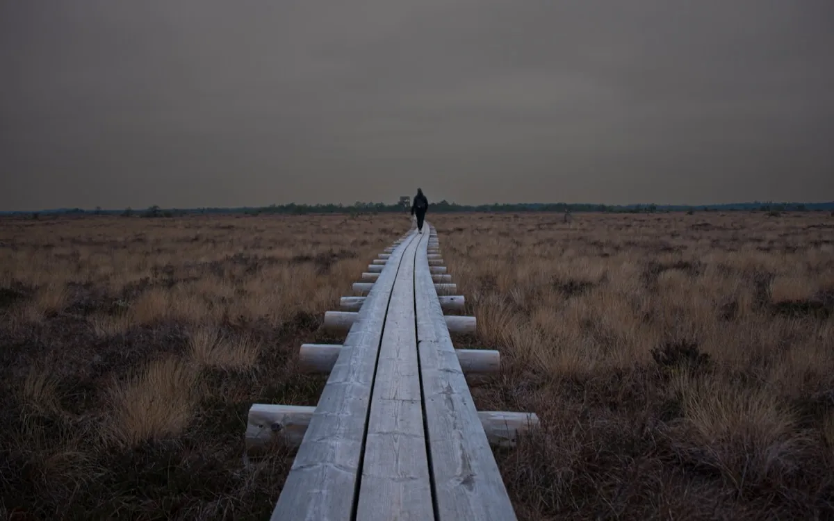
The Mer Bleue Bog represents one of Ottawa’s most unique natural environments and is recognized as a Ramsar Wetland of International Importance. This 1.2-km boardwalk trail winds through a 10,000-year-old peatland ecosystem that resembles northern Ontario tundra, despite being just 25 minutes from downtown. The bog formed after the Champlain Sea receded and represents one of the southernmost boreal-type peatlands in North America.
- Distance: 1.2 km loop (main boardwalk)
- Extended Options: 9.5 km of additional trails in the greater conservation area
- Time: 30-45 minutes (boardwalk), 2-3 hours (full area)
- Difficulty: Easy
- Elevation: Minimal (boardwalk is flat)
- Parking Address: Mer Bleue Trailhead, Ridge Road, Gloucester, ON (off Anderson Road)
- GPS Coordinates: 45.4049, -75.5068
- Parking: Free, approximately 40 spaces
- Accessibility: Fully wheelchair and stroller accessible
- Dogs: Not allowed on boardwalk (ecosystem protection)
- Best Season: Year-round; late September-early October for fall colours
The boardwalk features interpretive panels explaining the rare bog ecosystem, including carnivorous sundew plants, sphagnum mosses, and Labrador tea. Over 130 bird species have been recorded here, making it popular with birdwatchers, particularly during spring and fall migrations. The bog also supports black spruce and tamarack trees typically found much further north.
Insider Tip: Visit at dawn on a calm morning in late September when mist rises from the bog and the tamarack trees turn golden. The unique lighting creates exceptional photography opportunities unavailable elsewhere in Ottawa.
Pink Lake Trail
Pink Lake stands as the most popular trail in Gatineau Park, and for good reason. The 2.3-km loop circles a stunning meromictic lake with remarkable turquoise-green waters caused by unique chemical layering that prevents seasonal mixing. Despite its name, the lake is not pink but rather named after the Pink family who settled nearby in the 1800s. The lake’s unusual water chemistry creates conditions where the bottom waters have remained unchanged for over 10,000 years.
- Distance: 2.3 km loop
- Time: 45-60 minutes
- Difficulty: Easy to Moderate (includes stairs)
- Elevation: 50 metres gain
- Trail Surface: Packed earth, wooden boardwalks, stone stairs
- Parking Address: Pink Lake Parking Lot (P13), Gatineau Parkway, Chelsea, QC
- GPS Coordinates: 45.4919, -75.8217
- Parking Fee: $5-15 depending on duration (free on Tuesdays)
- Accessibility: Not wheelchair accessible due to stairs
- Dogs: Not allowed (ecosystem protection)
- Best Season: Year-round; early morning on weekdays to avoid crowds
The trail includes multiple elevated viewing platforms offering different perspectives of the lake’s striking colour. The northern section features the most dramatic viewpoints, while the southern portion winds through mature maple forest particularly beautiful during fall foliage. Swimming and fishing are prohibited to protect the fragile ecosystem.
Insider Tip: The lake’s colour appears most vibrant on overcast days when there is no glare on the water. For photography, the northern lookout platforms provide the best angles. Arrive before 9 AM on summer weekends as the small parking lot fills quickly.
Champlain Lookout Loop
For those seeking maximum scenic impact with minimal effort, the Champlain Lookout Loop delivers. This 1.1-km trail along the Eardley Escarpment provides panoramic views of the Ottawa Valley stretching 40 kilometres to the horizon. The lookout sits at 335 metres elevation, making it one of the highest accessible points in the region. On clear days, you can see the Laurentian Mountains to the north and downtown Ottawa to the east.
- Distance: 1.1 km loop
- Time: 20-30 minutes
- Difficulty: Easy
- Elevation: 30 metres gain (mostly at start)
- Trail Surface: Packed gravel and natural surface
- Parking Address: Champlain Lookout, Champlain Parkway, Gatineau, QC
- GPS Coordinates: 45.5067, -75.9083
- Parking Fee: Free (follows Gatineau Parkway schedule)
- Accessibility: Main lookout platform is accessible; trail loop is not
- Dogs: Allowed on leash
- Best Season: Fall (peak foliage), sunset year-round
The viewing platform includes interpretive panels identifying visible landmarks. The short loop trail circles through mature forest with additional viewpoints. During peak foliage season in early to mid-October, the escarpment ridge transforms into a quilt of crimson, gold, and orange stretching to the horizon.
Insider Tip: The lookout faces west, making it perfect for sunset viewing. The Champlain Parkway closes to vehicles on Wednesday, Saturday, and Sunday afternoons during summer for active-use hours, so plan accordingly or enjoy the car-free experience on foot.
Hog’s Back Falls Loop
Located just 10 minutes from downtown Ottawa, Hog’s Back Falls offers an urban escape featuring a dramatic waterfall on the Rideau River. Named for the rock formation that resembles a pig’s back, this natural waterfall was modified during construction of the Rideau Canal in the 1820s. The 1.5-km loop trail circles the falls area and connects to the extensive Rideau Canal pathway system, allowing for extended walking or cycling.
- Distance: 1.5 km loop (extendable via canal paths)
- Time: 30-45 minutes
- Difficulty: Easy
- Elevation: 15 metres descent to river level
- Trail Surface: Paved paths, some natural surface trails
- Parking Address: Hog’s Back Park, Colonel By Drive at Hog’s Back Road, Ottawa, ON
- GPS Coordinates: 45.3728, -75.6964
- Parking Fee: Free, large lot available
- Accessibility: Paved portions are accessible; descent to falls viewing not accessible
- Dogs: Allowed on leash
- Best Season: Spring (dramatic water flow), year-round
The falls are most impressive during spring snowmelt from late March through May when water volumes peak. A pedestrian bridge crosses above the falls, providing excellent viewing and photography angles. The park includes picnic areas, washrooms, and connects to both the Rideau Canal Eastern Pathway and Western Pathway for those wanting longer walks.
Insider Tip: This trail works perfectly for lunch-hour hikes or quick after-work escapes. Combine with a walk along the canal pathway to Colonel By Drive for a 5-km round trip. In winter, the frozen falls create beautiful ice formations.
Jack Pine Trail
Part of the Stony Swamp Conservation Area, Jack Pine Trail offers one of Ottawa’s best birdwatching experiences. The 2.3-km loop features extensive boardwalk sections through wetlands where over 560 native plant species have been documented, along with 218 bird species.
- Distance: 2.3 km loop
- Time: 45-60 minutes
- Difficulty: Easy
- Elevation: Minimal (boardwalk is flat)
- Trail Surface: Wooden boardwalk and packed earth
- Parking Address: Stony Swamp Visitor Centre, 6219 Moodie Drive, Ottawa, ON
- GPS Coordinates: 45.3156, -75.8561
- Parking Fee: Free
- Accessibility: Boardwalk sections are wheelchair accessible
- Dogs: Allowed on leash
- Best Season: Spring (bird migration), year-round
The trail connects to the larger Stony Swamp trail network, allowing for extended hikes. The nearby Sarsaparilla Trail offers an additional 1.3 km loop through different forest types. The Stony Swamp Visitor Centre provides maps and seasonal programming.
Insider Tip: Spring mornings (May-June) offer the best bird activity. Bring binoculars to spot warblers, woodpeckers, and waterfowl in the wetland areas. The visitor centre hosts guided nature walks throughout the season.
Additional Easy Trails
| Trail Name | Distance | Time | Parking | Best Features |
|---|---|---|---|---|
| Sugarbush Trail | 1.9 km | 30 min | Free at P7 | Wheelchair accessible, maple forest, snowshoeing |
| Pioneers Trail | 1.3 km | 30-40 min | Free | Meadow wildflowers, forest transition zones |
| Chapman Mills Trail | 1.5 km | 30-45 min | Free | Boardwalks, Rideau River views, urban access |
| Beaver Pond Trail | 4 km | 60-90 min | Free at Stony Swamp | Active beaver lodges, wetland wildlife |
| Lime Kiln Trail | 4.2 km | 55 min | Free | Historic lime kilns, stroller-accessible sections |
| Mud Lake Loop | 2.8 km | 45-60 min | Free, Britannia | Wetland birds, fall colours, waterfowl |
| Ottawa River Pathway | Variable | Variable | Multiple free lots | Paved, scenic river views, connects to ByWard Market |
Moderate Trails for Regular Hikers

These trails offer more challenging terrain with notable elevation gain, typically requiring 1.5 to 3 hours to complete. Suitable for hikers with reasonable fitness who want rewarding views without extreme difficulty. Proper hiking footwear is recommended for all moderate trails.
King Mountain Trail
King Mountain represents the highest point in Gatineau Park at 344 metres above sea level, featuring an impressive 10 labeled lookout points along a compact 1.8-km loop. Despite the short distance, expect a moderately steep climb with 100 metres of elevation gain concentrated in the first 500 metres of trail. Each lookout offers different perspectives of the Ottawa Valley, Lac Meech, and the surrounding Gatineau Hills.
- Distance: 1.8 km loop
- Time: 45-75 minutes
- Difficulty: Moderate (steep initial climb)
- Elevation: 100 metres gain, summit at 344 metres
- Trail Surface: Rocky terrain, exposed roots, some scrambling
- Parking Address: King Mountain Parking Lot (P7), Gatineau Parkway, Chelsea, QC
- GPS Coordinates: 45.4917, -75.8650
- Parking Fee: $5-15 depending on duration
- Accessibility: Not accessible
- Dogs: Not allowed (ecosystem protection)
- Best Season: Year-round; fall for foliage, winter for snowshoeing
The trail delivers exceptional value for effort invested. Sunrise hikes reward early risers with stunning golden light over the Ottawa Valley. Fall foliage transforms the surrounding forest into a sea of colour visible from multiple vantage points. The summit area includes bare rock outcrops perfect for picnic breaks with panoramic views.
Insider Tip: For a longer adventure, combine King Mountain with the nearby Skyline Trail for a 7+ km loop hitting multiple lookouts. The King Mountain parking lot is smaller than Pink Lake and fills quickly on fall weekends, so arrive by 8 AM.
Lauriault Trail (Mackenzie King Estate)
This 4.5-km loop combines natural beauty with Canadian history at the former summer estate of Prime Minister William Lyon Mackenzie King, Canada’s longest-serving PM who held office for 22 years. The trail features the Bridal Veil Falls, historic cottage ruins collected from across Ontario, formal gardens, and scenic lookouts over the Ottawa Valley. Learn more about this historic site in our Mackenzie King Estate guide.
- Distance: 4.5 km loop (shorter options available)
- Time: 60-90 minutes (plus time exploring the estate)
- Difficulty: Moderate
- Elevation: 100 metres gain
- Trail Surface: Packed earth, some rocky sections, steps at waterfall
- Parking Address: Mackenzie King Estate Parking (P6), Barnes Road, Chelsea, QC
- GPS Coordinates: 45.4756, -75.8417
- Parking Fee: $5-15 depending on duration (free on Tuesdays)
- Accessibility: Estate grounds accessible; trails not accessible
- Dogs: Allowed on leash
- Best Season: Spring (best waterfall flow), fall (foliage)
Highlights include the Bridal Veil Falls (most impressive during spring snowmelt), the Abbey Ruins (collected stones from buildings across Canada), and interpretive panels detailing the eccentric Prime Minister’s spiritualist practices and seances. The estate’s gardens bloom throughout summer, and the tearoom operates during peak season.
Insider Tip: Spring offers the best waterfall flow, while fall brings spectacular foliage. The estate buildings are open from late May through mid-October. Combine with a visit to Kingsmere Lake for swimming access (small beach area near parking lot P6).
Carbide Willson Ruins Trail
History meets nature on this 2.6-km trail leading to the atmospheric ruins of Thomas Carbide Willson’s early 1900s fertilizer plant. Willson, the inventor who developed calcium carbide and made artificial gas lighting possible, built this facility on Meech Lake’s shore to develop phosphorus-based fertilizers. The abandoned industrial site now features moss-covered stone walls, a small dam with cascading water, and lakeside views creating an Instagram-worthy destination.
- Distance: 2.6-3.5 km (depending on route)
- Time: 60-90 minutes
- Difficulty: Easy to Moderate
- Elevation: 130 metres gain (via ridge trail option)
- Trail Surface: Forest paths, some rocky sections, root exposure
- Parking Address: Meech Lake Parking Lot (P12), Lac-Meech Road, Chelsea, QC
- GPS Coordinates: 45.5333, -75.8833
- Parking Fee: $5-15 depending on duration
- Accessibility: Not accessible
- Dogs: Allowed on leash
- Best Season: Year-round; summer for swimming, fall for foliage
The ruins create a hauntingly beautiful backdrop for photography, particularly in early morning fog or after fresh snowfall. Multiple trail options allow customizing your route: the direct lakeside path is easier, while the ridge trail adds elevation and viewpoints. After hiking, cool off at nearby O’Brien Beach on Meech Lake during summer months (lifeguard-supervised).
Insider Tip: The ruins are most photogenic at golden hour or on misty mornings. Combine with a swim at O’Brien Beach for a perfect summer half-day outing. The waterfall at the ruins flows year-round but is most impressive in spring.
South March Highlands Trail
One of Ottawa’s premier conservation areas, South March Highlands offers over 15 km of interconnected trails through old-growth forest featuring Canadian Shield terrain with exposed granite bedrock, vernal pools, and multiple scenic lookouts. The 2,000-hectare conservation forest serves as an important wildlife corridor connecting the Ottawa River to interior habitats, supporting species including Blanding’s turtles and numerous bird species.
- Distance: 8-15 km (multiple loop options)
- Time: 2-4 hours depending on route
- Difficulty: Moderate to Difficult
- Elevation: 60 metres total gain (rolling terrain)
- Trail Surface: Rocky Canadian Shield terrain, exposed roots, some wet sections
- Parking Address: Terry Fox Drive Trailhead, Kanata, ON (near Morgan’s Grant)
- Alternative Access: Klondike Road entrance
- GPS Coordinates: 45.3389, -75.9667
- Parking Fee: Free, limited spaces
- Accessibility: Not accessible (rough terrain)
- Dogs: Allowed on leash year-round
- Best Season: Fall for colours, year-round for hiking
Located in Kanata, this trail network offers an excellent half-day hiking option for those seeking more challenge than Gatineau Park’s shorter trails. Multiple loop options allow customizing distance and difficulty, from 3-km introductory loops to the full perimeter trail. The exposed granite outcrops provide scenic rest spots and natural viewpoints.
Insider Tip: The trails can be muddy in spring and after heavy rain. Waterproof hiking boots recommended. Mountain biking is permitted on designated trails, so be aware of sharing paths on weekends. The Klondike Road entrance provides easier access to some loops.
Additional Moderate Trails
| Trail Name | Distance | Time | Elevation | Parking | Key Features |
|---|---|---|---|---|---|
| Skyline Trail | 5.3 km | 2 hours | 80m | P7, $5-15 | Forest immersion, ridge views, connects to King Mountain |
| Lac Philippe Loop | 9.5 km | 3-4 hours | 100m | P17, $5-15 | Lakeshore hiking, beach access, wildlife viewing |
| Sheila McKee Park | 2.4 km | 45-60 min | 50m | Free | Winter frozen waterfall, Ottawa River views |
| Pine Grove Trail | 4.4 km | 1.5 hours | 30m | Free | Forest immersion, quiet, near Mer Bleue |
| Rockcliffe Park Trails | 3-5 km | 1-2 hours | 40m | Free | Lookouts, historic estate, urban access |
| Green’s Creek | 5 km | 1.5 hours | 30m | Free | Ravine forest, off-leash dog areas, creek views |
Challenging Trails for Experienced Hikers
These demanding routes feature significant elevation gain, longer distances, and more rugged terrain. Proper hiking boots with ankle support, adequate water (minimum 2 liters), snacks, and reasonable fitness are essential. Check weather forecasts before departing and inform someone of your hiking plan.
Wolf Trail
Wolf Trail ranks as the best overall challenging hike in Gatineau Park, combining two stunning lookouts with a well-maintained 8.3-km loop through diverse forest ecosystems. The initial steep climb rewards hikers with the Tawadina Lookout at 290 metres elevation, offering sweeping views of the Ottawa River Valley and the Gatineau Hills. The trail then descends through mixed forest before rising to the equally impressive Mahingan Lookout during the final stretch.
- Distance: 8.3 km loop
- Time: 2.5-3.5 hours
- Difficulty: Moderate to Difficult
- Elevation: 300 metres total gain, peak at 290 metres
- Trail Surface: Rocky terrain, exposed roots, steep sections, some scrambling
- Parking Address: Blanchet Beach Parking (P13), Lac-Philippe Road, Chelsea, QC
- GPS Coordinates: 45.5917, -75.9167
- Parking Fee: $5-15 depending on duration
- Accessibility: Not accessible
- Dogs: Allowed on leash (not in beach picnic areas)
- Best Season: Spring through fall; snowshoeable in winter with NCC pass
The panoramic views of the Ottawa River Valley from both lookouts make this trail a local favourite among serious hikers and trail runners. The name “Wolf Trail” (Sentier du Loup) reflects the area’s wildlife heritage, though wolf sightings are rare. The adjacent Blanchet Beach offers swimming to cool down after summer hikes, with lifeguard supervision during peak season.
Insider Tip: The trail is popular with sunset seekers as the Tawadina Lookout faces west. Start by 5 PM in summer to catch golden hour light. The clockwise direction provides the steepest climb first when you’re fresh, with the more gradual descent at the end.
Luskville Falls Trail
The most challenging trail readily accessible from Ottawa, Luskville Falls delivers dramatic elevation with 290 metres of gain over a 4.8-km loop. The trail features a seasonal waterfall, fire tower ridge with sweeping Ottawa Valley views, and the steepest maintained climb in Gatineau Park. Two route options exist: the North Trail offers a more gradual approach, while the South Trail provides a steeper, more direct ascent.
- Distance: 4.8 km loop (or 3 km out-and-back to falls only)
- Time: 2.5-3.5 hours
- Difficulty: Difficult
- Elevation: 290 metres gain
- Trail Surface: Rocky escarpment, steep sections, some scrambling, slippery when wet
- Parking Address: Luskville Falls Parking Lot, Chemin de la Montagne, Luskville, QC (off Highway 148)
- GPS Coordinates: 45.5500, -76.0167
- Parking Fee: Free, roadside parking area
- Accessibility: Not accessible
- Dogs: Allowed on leash
- Best Season: Spring (waterfall flow), fall (foliage)
The steep escarpment climb challenges even fit hikers but rewards with expansive views of the Ottawa River Valley stretching toward Parliament Hill. The fire tower site at the summit provides a 180-degree panorama. The waterfall is most impressive from late March through May during snowmelt; by July, it typically reduces to a trickle.
Insider Tip: The trail is extremely slippery when wet; avoid during or after rain. The South Trail is steeper but shorter. For the best waterfall experience, visit within two weeks of snowmelt starting, typically late March to mid-April. Bring hiking poles for the steep descent.
Yellow Box Trail
For the ultimate Gatineau Park challenge, Yellow Box Trail spans 14 km with 480 metres of total elevation gain across multiple demanding climbs. This unofficial, unmaintained trail follows the Eardley Escarpment ridge with sparse yellow rectangular markings (hence the name) and requires navigation skills. The trail rewards experienced hikers with solitude and wilderness immersion unavailable on marked trails.
- Distance: 14 km (two interconnected loop system)
- Time: 6-8 hours
- Difficulty: Difficult (navigation skills required)
- Elevation: 480 metres total gain across multiple climbs
- Trail Surface: Unmarked wilderness, steep scrambles, rock outcrops, minimal trail maintenance
- Parking Address: Chemin Eardley-Masham shoulder, near Luskville, QC (no facilities)
- GPS Coordinates: 45.5583, -76.0333
- Parking Fee: Free, limited roadside parking
- Accessibility: Not accessible
- Dogs: Allowed on leash
- Best Season: Late spring through fall (avoid wet conditions)
A mapping app or GPS device is strongly recommended, as trail markings are minimal and easy to miss. The famous yellow box hikers’ log at the summit ridge invites contributions to a decades-long tradition of recording names and dates. This trail sees fewer crowds than any other major Gatineau Park route, offering true wilderness solitude.
Insider Tip: Download offline maps before departing. The trail is not recommended for solo hikers unfamiliar with backcountry navigation. Bring extra water and food as the duration often exceeds expectations. Early start recommended to complete before dark.
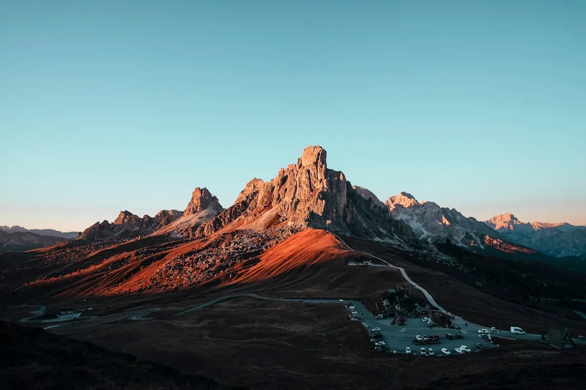
Eagle’s Nest Trail (Calabogie)
Located about 90 minutes from Ottawa in the Madawaska Highlands, Eagle’s Nest delivers the region’s most dramatic cliff-edge lookout with sheer 75-meter drops overlooking Calabogie Lake and the surrounding mountains. The trail climbs through mixed forest to a sacred Indigenous site that has been significant to the Algonquin people for centuries. The exposed cliff-top viewpoint offers 180-degree panoramas that have made this one of Ontario’s most photographed hiking destinations.
- Distance: 3.5 km out-and-back (or 5 km loop option)
- Time: 1.5-2.5 hours
- Difficulty: Moderate to Difficult
- Elevation: 180 metres gain
- Trail Surface: Forest path, rocky sections, steep climb to summit
- Parking Address: Eagle’s Nest Trailhead, near Calabogie Peaks Resort, 30 Barrett Chute Road, Calabogie, ON
- GPS Coordinates: 45.2833, -76.7667
- Parking Fee: Free at trailhead
- Accessibility: Not accessible
- Dogs: Allowed on leash
- Best Season: Fall (foliage), year-round
The exposed cliff-top lookout is not suitable for those with fear of heights or young children. The edge is unfenced and drops straight down. Arrive early for the best photography light and fewer crowds, particularly on fall weekends when the trail becomes very popular. The loop option adds distance but provides a less steep descent.
Insider Tip: Combine with a visit to the Calabogie Brewing Company or Calabogie Peaks Resort for post-hike refreshments. The fall colours here peak slightly earlier than Ottawa (late September to early October) due to the higher elevation and northern location.
Lusk Cave Trail
Combining hiking with cave exploration, this 8.5-km trail leads to one of Quebec’s most accessible marble cave systems. The trail winds through mature forest before descending to the Lusk Cave entrance, where adventurous hikers can wade through passages in water ranging from ankle to waist deep. The cave formed over 12,500 years ago as glacial meltwater carved through the marble bedrock, creating a 150-meter labyrinth of passages.
- Distance: 8.5 km loop (including cave exploration)
- Time: 4-5 hours (including cave time)
- Difficulty: Moderate to Challenging (cave adds difficulty)
- Elevation: 220 metres gain
- Trail Surface: Forest paths, rocky terrain, cave requires wading
- Parking Address: Philippe Lake Parking (P19), Lac-Philippe Road, Chelsea, QC
- GPS Coordinates: 45.6083, -76.0250
- Parking Fee: $5-15 depending on duration
- Accessibility: Not accessible
- Dogs: Not allowed in cave; allowed on trail portion
- Best Season: July-September (warmest water temperatures)
Special Equipment Required:
- Swimsuit or quick-dry clothing
- Water shoes with grip (not flip-flops)
- Headlamp or waterproof flashlight (helmet-mounted preferred)
- Helmet recommended (cave ceiling is low in sections)
- Waterproof bag for electronics
- Change of dry clothes for after
The cave requires wading through cold water (approximately 10-15°C even in summer) in near-darkness. Some passages require crawling and ducking. The experience is not claustrophobic but requires comfort in dark, wet environments. The trail concludes at Parent Beach on Lac Philippe, where you can warm up and swim.
Insider Tip: Go on a hot day when the cold cave water feels refreshing rather than shocking. Pack your cave gear in a waterproof bag. The cave is most comfortable to explore from mid-July through August when water levels are lowest and temperatures highest. Groups should stay together in the cave.
Gatineau Park: Top 7 Must-Hike Trails
Gatineau Park spans 361 square kilometres just 15 minutes from downtown Ottawa, making it Canada’s second-most-visited federal park after Banff. The park offers the largest concentration of quality hiking trails in the region, with terrain ranging from gentle lakeside paths to challenging escarpment climbs.
| Rank | Trail | Distance | Difficulty | Why Visit |
|---|---|---|---|---|
| 1 | Wolf Trail | 8.3 km | Mod-Diff | Best overall challenging hike |
| 2 | Pink Lake | 2.3 km | Easy-Mod | Iconic turquoise lake |
| 3 | King Mountain | 1.8 km | Moderate | Highest point, 10 lookouts |
| 4 | Champlain Loop | 1.1 km | Easy | Quick access to peak views |
| 5 | Lauriault Trail | 4.5 km | Moderate | History, waterfalls, lookouts |
| 6 | Lusk Cave Trail | 8.5 km | Mod-Chall | Unique cave exploration |
| 7 | Yellow Box Trail | 14 km | Difficult | Wilderness adventure |
Gatineau Park Access and Fees
2026 Parking Fees:
| Duration | Fee |
|---|---|
| Up to 1 hour | $5 |
| Up to 4 hours | $10 |
| Up to 9 hours | $13 |
| All day | $15 |
| Annual Pass | $90 |
| Winter Season Pass | $50 |
| Summer Season Pass | $65 |
Free Parking: Available on Tuesdays at most lots (P6, P7, P13). Some roadside trailheads (Luskville Falls) remain free year-round.
Payment Methods: Credit card at pay stations or HotSpot Parking app.
Parkway Access Schedule: The Gatineau Parkway operates on seasonal schedules. During summer (May-October), many sections close to vehicles Wednesday, Saturday, and Sunday afternoons from 9 AM to 5 PM for active use (cycling, running, rollerblading). Check ncc-ccn.gc.ca for current schedules.
Visitor Centre: 33 Scott Road, Chelsea, QC. Open daily with maps, passes, equipment rentals, and seasonal programming.
Quick Reference: Trails by Difficulty Level
Finding the right trail for your fitness level is essential for an enjoyable hiking experience. Here is a quick breakdown of all trails covered in this guide organized by difficulty.
Easy Trails (Minimal Elevation, Under 2 Hours)
Perfect for beginners, families with young children, seniors, and those seeking a relaxed nature experience.
| Trail | Distance | Elevation | Highlight |
|---|---|---|---|
| Mer Bleue Bog Boardwalk | 1.2 km | Flat | Wheelchair accessible, unique bog ecosystem |
| Champlain Lookout Loop | 1.1 km | 30m | Fastest route to panoramic views |
| Hog’s Back Falls Loop | 1.5 km | 15m | Urban waterfall, connects to Rideau pathway |
| Jack Pine Trail | 2.3 km | Flat | Birdwatching, extensive boardwalk |
| Sugarbush Trail | 1.9 km | Minimal | Wheelchair accessible, maple forest |
| Pioneers Trail | 1.3 km | Minimal | Meadow wildflowers, forest transition |
| Mud Lake Loop | 2.8 km | Minimal | Wetland birds, fall colours |
Moderate Trails (50-150m Elevation, 1-3 Hours)
Suitable for hikers with reasonable fitness seeking more challenge and scenic variety.
| Trail | Distance | Elevation | Highlight |
|---|---|---|---|
| Pink Lake Trail | 2.3 km | 50m | Iconic turquoise water, viewing platforms |
| King Mountain Trail | 1.8 km | 100m | 10 labeled lookouts, highest point |
| Lauriault Trail | 4.5 km | 100m | Historic estate, waterfall, gardens |
| Carbide Willson Ruins | 2.6-3.5 km | 130m | Atmospheric ruins, lake swimming nearby |
| Skyline Trail | 5.3 km | 80m | Forest immersion, ridge views |
| Sheila McKee Park | 2.4 km | 50m | Frozen waterfall in winter |
Challenging Trails (200m+ Elevation, 3+ Hours)
For experienced hikers seeking significant physical challenge and wilderness immersion.
| Trail | Distance | Elevation | Highlight |
|---|---|---|---|
| Wolf Trail | 8.3 km | 300m | Best overall challenging hike, dual lookouts |
| Luskville Falls Trail | 4.8 km | 290m | Steepest climb, spring waterfall |
| South March Highlands | 8-15 km | 60m | Canadian Shield terrain, old-growth forest |
| Eagle’s Nest (Calabogie) | 3.5-5 km | 180m | Dramatic cliff-edge lookout |
| Lusk Cave Trail | 8.5 km | 220m | Cave exploration, beach finish |
| Yellow Box Trail | 14 km | 480m | Ultimate challenge, wilderness solitude |
Dog-Friendly Hiking Trails Near Ottawa

Planning to bring your furry friend? These trails welcome leashed dogs during the warmer months (typically April through early November). Always bring water, waste bags, and keep your dog on a leash unless in designated off-leash areas.
For more pet-friendly activities, check out our complete dog-friendly Ottawa guide covering parks, patios, and services.
Top Dog-Friendly Trails
| Trail | Distance | Difficulty | Special Features |
|---|---|---|---|
| Beaver Pond Trail | 4 km | Easy | Ponds dogs love, wetland wildlife |
| Conroy Pit Loop | 3.2 km | Easy | Off-leash dog park nearby |
| Wolf Trail | 8.3 km | Mod-Diff | Beach access at end |
| South March Highlands | 8 km | Moderate | Conservation forest |
| Sheila McKee Park | 2.4 km | Moderate | Waterfall, river views |
| Champlain Loop | 1.1 km | Easy | Quick escarpment walk |
| Carbide Willson Ruins | 2.6 km | Easy-Mod | Historic ruins, lake |
Off-Leash Dog Areas
- Bruce Pit (Stony Swamp): 5 km of trails with large open field
- Conroy Pit: Off-leash dog park adjacent to hiking trails
- Beaver Pond Trail: Off-leash allowed in designated sections
Important Note: Dogs are NOT allowed on Pink Lake Trail, King Mountain Trail, or Mer Bleue Bog to protect sensitive ecosystems.
Dog-Friendly Hiking Tips
Before You Go:
- Ensure your dog is current on vaccinations and protected against ticks
- Bring a leash (6 feet maximum on most trails)
- Pack waste bags and remove all waste from trails
- Carry extra water for your dog (they dehydrate faster than humans)
- Check trail conditions during hot weather (paws can burn on hot rocks)
On the Trail:
- Keep dogs leashed unless in designated off-leash areas
- Yield to other hikers by stepping aside and controlling your dog
- Prevent dogs from chasing wildlife or entering sensitive habitat areas
- Cool dogs at available water sources but avoid sensitive wetlands
- Watch for signs of overheating: excessive panting, drooling, stumbling
Best Dog-Friendly Swimming Spots:
- Blanchet Beach (end of Wolf Trail) - dogs allowed in designated areas
- Meech Lake - dogs permitted at certain access points
- South March Highlands - small ponds along trails
- Green’s Creek - creek access for cooling off
Trails with Waterfalls and Scenic Lookouts

Nothing rewards a hike quite like a waterfall or sweeping vista. These trails deliver dramatic natural features worth the journey.
Waterfall Trails
| Trail | Waterfall Type | Best Season | Flow Reliability |
|---|---|---|---|
| Hog’s Back Falls | Urban cascade | Spring | Year-round |
| Lauriault/Bridal Veil | Multi-drop cascade | Spring-Fall | Reliable |
| Luskville Falls | Escarpment cascade | Spring | Seasonal (dries summer) |
| Sheila McKee Park | Escarpment cascade | Winter | Best frozen |
| Princess Louise Falls | Multi-drop falls | Spring-Summer | Reliable |
| Carbide Willson Ruins | Small waterfall | Year-round | Reliable |
Best Lookout Trails
| Trail | Lookout Features | Elevation Gain |
|---|---|---|
| King Mountain | 10 labeled lookouts, valley panorama | 100m |
| Wolf Trail | Tawadina + Mahingan dual lookouts | 300m |
| Champlain Loop | Eardley Escarpment views | Minimal |
| Eagle’s Nest | Cliff-edge panorama | Significant |
| Rock Dunder Summit | Lake panorama, ridgeline | Significant |
Best Trails for Families with Children
Planning a family hiking adventure? These trails offer safe, engaging experiences for children of all ages, with features that keep young hikers interested throughout the journey.
Top Family Hiking Picks
| Trail | Age Suitability | Distance | Why Kids Love It |
|---|---|---|---|
| Mer Bleue Bog | All ages | 1.2 km | Boardwalk exploration, carnivorous plants |
| Pink Lake | Ages 5+ | 2.3 km | Colorful turquoise water, viewing platforms |
| Jack Pine Trail | All ages | 2.3 km | Boardwalk, wildlife spotting |
| Hog’s Back Falls | All ages | 1.5 km | Waterfall views, playground nearby |
| Lusk Cave Trail | Ages 8+ | 8.5 km | Cave exploration adventure |
| Mackenzie King Estate | Ages 4+ | 4.5 km | Ruins exploration, estate gardens |
Family Hiking Tips
For Toddlers and Preschoolers (Ages 2-5):
- Choose stroller-accessible trails: Mer Bleue Bog, Sugarbush Trail, Lime Kiln Trail
- Plan for 30-45 minute excursions
- Bring snacks and distractions for rest breaks
- Best times: Morning when energy is highest
For Elementary School Kids (Ages 6-10):
- Introduce moderate trails: Pink Lake, King Mountain, Lauriault Trail
- Make it a game with nature scavenger hunts
- Allow 1.5x the adult time estimate
- Bring binoculars for wildlife spotting
For Tweens and Teens (Ages 11+):
- Challenge them with Wolf Trail or Lusk Cave
- Let them navigate with a trail map
- Plan post-hike rewards (swimming at Philippe Lake, ice cream)
Best Trails for Photography
Ottawa-area trails offer exceptional photography opportunities year-round. These locations provide the most dramatic subjects and lighting conditions for photographers of all skill levels.
Top Photography Trails
| Trail | Best Subjects | Optimal Time | Equipment Tip |
|---|---|---|---|
| Pink Lake | Turquoise water, reflections | Overcast days, golden hour | Polarizing filter essential |
| Champlain Lookout | Valley panoramas, sunsets | Sunset, fall foliage | Wide-angle lens |
| Mer Bleue Bog | Mist, fall colours, wildlife | Dawn in September-October | Tripod for low light |
| Eagle’s Nest | Cliff panorama, lake views | Golden hour | Wide-angle, drone (check rules) |
| Carbide Willson Ruins | Historic ruins, waterfalls | Foggy mornings, winter | Long exposure for waterfall |
| King Mountain | Layered mountain views | Sunrise, fall foliage | Telephoto for compression |
| Luskville Falls | Waterfall, valley views | Spring snowmelt | ND filter for long exposure |
Photography Seasons
Spring (April-May): Waterfalls at peak flow, spring wildflowers, bird migrations, dramatic clouds
Summer (June-August): Lush greenery, morning mist, lake reflections, wildlife activity
Fall (September-October): Peak foliage, golden hour warmth, fog in valleys, dramatic skies
Winter (December-March): Snow-covered landscapes, frozen waterfalls, minimal crowds, clean compositions
Seasonal Hiking Recommendations
Different seasons offer unique hiking experiences in the Ottawa-Gatineau region. Here are the best trails for each time of year.
Spring (April-May)
| Trail | Why Visit in Spring |
|---|---|
| Luskville Falls | Waterfall at peak flow |
| Hog’s Back Falls | Dramatic spring runoff |
| Lauriault Trail | Bridal Veil Falls flowing |
| Mud Lake Loop | Bird migration peak |
| Jack Pine Trail | Returning songbirds |
Spring Tips: Trails can be muddy; waterproof boots essential. Ticks become active; check yourself after hikes. Waterfalls peak 2-4 weeks after snowmelt begins.
Summer (June-August)
| Trail | Why Visit in Summer |
|---|---|
| Lusk Cave | Best cave exploration weather |
| Wolf Trail + Beach | Swim at Blanchet Beach after |
| Lac Philippe Loop | Beach access, swimming |
| Pink Lake | Early morning for fewer crowds |
| South March Highlands | Shaded forest, cooler temps |
Summer Tips: Start early to beat heat and crowds. Bring insect repellent. Carry extra water (minimum 2L for moderate hikes). Swim at Philippe Lake beaches after hiking.
Fall (September-October)
| Trail | Why Visit in Fall |
|---|---|
| Champlain Lookout | Escarpment foliage panorama |
| King Mountain | 10 lookouts through colour |
| Mer Bleue Bog | Tamarack and grass colours |
| Pink Lake | Forest reflection on water |
| Eagle’s Nest | Calabogie foliage views |
Fall Tips: Peak colour typically October 5-20. Weekdays are significantly less crowded. Layers essential as temperatures vary. Fall colours peak earlier at higher elevations and northern locations.
Winter (December-March)
| Trail | Why Visit in Winter |
|---|---|
| Sugarbush Trail | Snowshoeing, maple forest |
| Trails 60 & 61 | Beginner snowshoeing |
| Wolf Trail | Snowshoeing adventure |
| Sheila McKee Park | Frozen waterfall views |
| Greenbelt Trails | Winter hiking, free access |
Winter Tips: NCC pass required for most Gatineau Park winter trails ($12-22). Dress in layers. Microspikes helpful for icy conditions. Shorter daylight hours limit hiking time. Gatineau Park Visitor Centre rents snowshoes (~$15/day).
Trails by Distance from Downtown Ottawa
Planning your hiking day around drive time? Here are the best options organized by distance from Parliament Hill.
10-15 Minutes from Downtown
| Trail | Drive Time | Distance | Highlights |
|---|---|---|---|
| Hog’s Back Falls | 10 min | 1.5 km | Waterfall, urban escape |
| Chapman Mills | 15 min | 1.5 km | Boardwalks, Rideau River |
| Pine Grove Trail | 15 min | 4.4 km | Forest immersion |
20-30 Minutes from Downtown
| Trail | Drive Time | Distance | Highlights |
|---|---|---|---|
| Mer Bleue Bog | 25 min | 1.5 km | Unique bog ecosystem |
| Pink Lake | 25 min | 2.3 km | Turquoise meromictic lake |
| Jack Pine Trail | 25 min | 2.3 km | Birdwatching, boardwalk |
| Mud Lake Loop | 20 min | 2.8 km | Wetland birds, fall colours |
30-45 Minutes from Downtown
| Trail | Drive Time | Distance | Highlights |
|---|---|---|---|
| King Mountain | 35 min | 1.8 km | Highest point, panoramic views |
| Wolf Trail | 40 min | 8.3 km | Best challenging hike |
| Luskville Falls | 45 min | 4.2 km | Dramatic escarpment climb |
| South March Highlands | 30 min | 8 km | Old-growth forest |
60+ Minutes from Downtown
| Trail | Drive Time | Distance | Highlights |
|---|---|---|---|
| Eagle’s Nest (Calabogie) | 90 min | 8 km | Dramatic cliff lookout |
| Oiseau Rock | 120 min | 10 km | Summit lake swimming |
| Rock Dunder | 90 min | 3.9 km | Panoramic lake views |
Winter Hiking and Snowshoeing Options
Ottawa’s trails transform into winter wonderlands from December through March. Several trails are specifically designated for winter hiking and snowshoeing, while others require activity passes.
Winter Trail Passes (2026 Season)
- Full Activity Pass: $22 adult, $17 youth/senior, $49 family (snowshoe + XC skiing + fat biking)
- Snowshoe-Only Pass: $12 adult, $9 youth/senior, $27 family
- Purchase: Online, Gatineau Park Visitor Centre, or parking lot machines
Best Winter Trails
| Trail | Distance | Activity | Pass Required |
|---|---|---|---|
| Lauriault Trail | 5 km | Hiking/Snowshoe | NCC day pass |
| Sugarbush Trail | 1.9 km | Hiking/Snowshoe | NCC day pass |
| Wolf Trail | 8.3 km | Snowshoe | NCC day pass |
| Jack Pine Trail | 2.3 km | Snowshoe | Free |
| Trails 60 & 61 | Varies | Snowshoe | NCC day pass |
The Gatineau Park Visitor Centre rents snowshoes (approximately $15/day) for those without equipment.
After a winter hike, warm up with skating on the Rideau Canal Skateway or explore the Winterlude festival activities.
Trail Safety Tips
Hiking near Ottawa is generally safe, but proper preparation ensures an enjoyable experience. The region’s trails range from urban paths to remote wilderness, each with different safety considerations.
Essential Gear Checklist
Day Hike Essentials (All Trails):
- Sturdy hiking boots or shoes with good traction
- Weather-appropriate layers (temperatures can vary significantly at elevation)
- Minimum 1 liter of water per 2 hours of hiking
- Snacks or lunch for longer hikes
- Sunscreen and insect repellent (spring/summer)
- Trail map or downloaded offline map
- Fully charged phone
- First aid kit for longer trails
Moderate to Challenging Trail Additions:
- Hiking poles (helpful for steep descents)
- Extra layers and rain jacket
- Headlamp (for unexpected delays)
- Emergency whistle
- Backup snacks and water
- Blister treatment supplies
Winter Hiking Additions:
- Microspikes or crampons for icy conditions
- Hand and toe warmers
- Extra insulation layers
- Gaiters for deep snow
- Sunglasses (snow glare)
Trail Etiquette and Leave No Trace
Following proper trail etiquette protects the environment and ensures enjoyable experiences for all visitors.
Leave No Trace Principles:
- Stay on marked trails to protect vegetation and prevent erosion
- Pack out all garbage including fruit peels and food scraps
- Avoid creating new trails or shortcuts
- Do not remove plants, rocks, or other natural materials
- Respect wildlife by observing from a distance
- Minimize campfire impacts (no fires on Gatineau Park trails)
Trail Sharing Etiquette:
- Yield to uphill hikers on narrow trails (they have right of way)
- Step aside for faster hikers to pass safely
- Announce your presence when approaching from behind
- Keep dogs under control and on designated trails
- Share trail conditions on hiking apps for fellow hikers
- Keep noise levels reasonable to respect wildlife and other hikers
Emergency Preparedness
Before Hiking:
- Tell someone your hiking plan and expected return time
- Know the trail difficulty before starting
- Check weather forecasts and avoid hiking during severe weather
- Verify trail conditions on NCC website or hiking apps
- Ensure your phone is fully charged
During Your Hike:
- Turn back if conditions deteriorate
- Stay on marked trails to avoid getting lost
- Keep your phone accessible for emergency calls
- Know the signs of hypothermia and heat exhaustion
Emergency Contacts:
- Emergency: 911 (provide trail name and last known location)
- NCC non-emergency: 613-239-5000
- Quebec poison control: 1-800-463-5060
- Ontario poison control: 1-800-268-9017
Seasonal Safety Considerations
Spring (April-May):
- Trails may be muddy and slippery
- Streams may be swollen from snowmelt
- Tick season begins - wear long pants and check yourself after hiking
- Some trails may be closed for spring maintenance
Summer (June-August):
- Carry extra water to prevent dehydration
- Start early to avoid midday heat
- Apply insect repellent (mosquitoes and black flies peak in June)
- Be aware of thunderstorm potential in afternoons
Fall (September-October):
- Daylight hours shorten - start earlier and plan accordingly
- Fallen leaves can obscure trail markings
- Hunting season begins in some areas - wear bright colours
- Temperatures can drop rapidly at elevation
Winter (December-March):
- Trails may be icy - wear traction devices
- Daylight is limited (sunrise ~7:30 AM, sunset ~4:30 PM)
- Dress in layers to manage temperature changes
- Carry emergency supplies in case of unexpected delays
- NCC pass required for Gatineau Park winter trails
Best Trails for Fall Foliage
Peak fall colours typically arrive in the first two to three weeks of October, transforming Ottawa’s forests into spectacular displays of crimson, gold, and orange. The region’s mix of maple, oak, beech, birch, and tamarack creates diverse colour palettes depending on elevation and location.
Understanding Fall Colour Timing
Fall colour progression follows predictable patterns that help plan optimal visits:
Late September: Tamaracks and grasses at Mer Bleue begin turning gold. Higher elevation areas of Gatineau Park show early colour.
Early October (Oct 1-10): Peak colour begins at higher elevations. King Mountain, Champlain Lookout, and escarpment trails reach optimal viewing.
Mid-October (Oct 10-20): Peak colour at most trails. Lower elevations and valley trails join the display. This represents the busiest hiking period.
Late October: Colours fade at higher elevations but remain vibrant in protected valleys. Fallen leaves create colorful ground cover.
Top Fall Foliage Trails
| Trail | Peak Time | Colour Highlights | Best Viewing Point |
|---|---|---|---|
| Champlain Lookout | Early-mid Oct | Escarpment quilt panorama | Western viewpoint at sunset |
| Mer Bleue Bog | Late Sept-early Oct | Yellow tamarack and grasses | Boardwalk overlook platforms |
| Mackenzie King Estate | Mid Oct | Historic estate amid gold/crimson | Abbey Ruins viewpoint |
| Pink Lake | Early-mid Oct | Forest reflection on turquoise water | Northern viewing platforms |
| King Mountain | Mid Oct | 360-degree colour panorama | Summit lookout points |
| Mud Lake Loop | Mid Oct | Wetland reflections, rare plants | Loop through wet meadows |
| Eagle’s Nest | Late Sept-early Oct | Calabogie lake and mountain views | Cliff summit |
| Wolf Trail | Mid Oct | Dual lookouts over colour canopy | Tawadina and Mahingan lookouts |
Fall Hiking Tips
Beat the Crowds:
- Visit on weekdays when parking lots are manageable
- Arrive before 9 AM on weekends
- Consider lesser-known trails like Wolf Trail or Carbide Ruins
- Avoid Thanksgiving weekend (busiest of the year)
Photography Tips for Fall Colours:
- Overcast days enhance colour saturation without harsh shadows
- Golden hour (1 hour after sunrise, 1 hour before sunset) adds warmth
- Use a polarizing filter to reduce glare and boost colour intensity
- Look for water reflections at Pink Lake and Mud Lake
- Include foreground elements to add depth to panoramas
Pro Tip: Visit on weekdays to avoid the significant crowds that gather at popular lookouts during peak foliage weekends. Champlain Lookout parking can fill by 10 AM on sunny October Saturdays.
Combining Hiking with Other Ottawa Activities
Make your hiking adventure part of a full Ottawa experience. After morning trails, explore:
- ByWard Market for lunch and shopping (15 minutes from most Gatineau Park trailheads)
- Westboro Village for trendy cafes and boutiques near western trails
- Best coffee shops in Ottawa to recharge with specialty coffee after your hike
- The Glebe neighbourhood for post-hike brunch and boutique shopping
- Summer swimming at Philippe Lake (lifeguard-supervised beaches)
- Winter activities including skating and Winterlude events
Trail Comparison Table
| Trail | Distance | Difficulty | Time | Elevation | Dogs | Parking | Best For |
|---|---|---|---|---|---|---|---|
| Mer Bleue Bog | 1.2 km | Easy | 30-45 min | Minimal | No | Free | Unique bog ecosystem, accessibility |
| Pink Lake | 2.3 km | Easy-Mod | 45-60 min | 50m | No | $5-15 | Iconic turquoise lake |
| Champlain Loop | 1.1 km | Easy | 20-30 min | 30m | Yes | Free | Quick panoramic views, sunset |
| Hog’s Back Falls | 1.5 km | Easy | 30-45 min | 15m | Yes | Free | Urban waterfall, convenience |
| Jack Pine Trail | 2.3 km | Easy | 45-60 min | Minimal | Yes | Free | Birdwatching, boardwalk |
| King Mountain | 1.8 km | Moderate | 45-75 min | 100m | No | $5-15 | 10 panoramic lookouts |
| Lauriault Trail | 4.5 km | Moderate | 60-90 min | 100m | Yes | $5-15 | History + waterfalls |
| Carbide Ruins | 2.6-3.5 km | Easy-Mod | 60-90 min | 130m | Yes | $5-15 | Historic ruins, lake views |
| South March | 8-15 km | Mod-Diff | 2-4 hours | 60m | Yes | Free | Old-growth forest, Canadian Shield |
| Wolf Trail | 8.3 km | Mod-Diff | 2.5-3.5 hr | 300m | Yes | $5-15 | Best challenging hike, dual lookouts |
| Luskville Falls | 4.8 km | Difficult | 2.5-3.5 hr | 290m | Yes | Free | Dramatic escarpment, waterfall |
| Eagle’s Nest | 3.5-5 km | Mod-Diff | 1.5-2.5 hr | 180m | Yes | Free | Cliff-edge views, photography |
| Lusk Cave | 8.5 km | Mod-Chall | 4-5 hours | 220m | Partial | $5-15 | Cave exploration adventure |
| Yellow Box | 14 km | Difficult | 6-8 hours | 480m | Yes | Free | Wilderness solitude, challenge |
FAQ
Q: Do I need to pay for parking at Gatineau Park trails?
Yes, most Gatineau Park parking lots charge fees ranging from $5 (1 hour) to $15 (all day). Annual passes cost $90. Tuesdays are free at most lots. Many Greenbelt trails (like Mer Bleue and Jack Pine) have free parking year-round.
Q: Which hiking trails near Ottawa are best for beginners?
Mer Bleue Bog (wheelchair-accessible boardwalk), Champlain Lookout Loop (quick scenic views), and Hog’s Back Falls Loop (urban waterfall walk) offer the easiest terrain with rewarding experiences.
Q: Are dogs allowed on Gatineau Park trails?
Many trails welcome leashed dogs, including Wolf Trail, Champlain Loop, and Carbide Willson Ruins. However, dogs are prohibited on Pink Lake, King Mountain, and Mer Bleue Bog to protect sensitive ecosystems.
Q: What is the best hiking trail near Ottawa for fall colours?
Champlain Lookout Loop offers the quickest access to spectacular fall foliage views. For a longer experience, Mackenzie King Estate/Lauriault Trail combines fall colours with waterfalls and historic sites.
Q: Can I hike in Gatineau Park during winter?
Yes, several trails are designated for winter hiking and snowshoeing. An NCC winter activity pass is required ($12-22 depending on activities). Trails 60/61 near the Visitor Centre are recommended for beginners.
Q: Which trail has the best waterfall near Ottawa?
Luskville Falls offers the most dramatic waterfall experience, though it only flows during spring snowmelt. For year-round waterfalls, Hog’s Back Falls (urban) and Lauriault/Bridal Veil Falls (Gatineau Park) are reliable options.
Q: How far is Pink Lake from downtown Ottawa?
Pink Lake is approximately 25 minutes from downtown Ottawa. The trail is located in Gatineau Park, Quebec, accessible via the Gatineau Parkway.
Q: Are there hiking trails near Ottawa with swimming spots?
Yes, Lac Philippe offers lifeguard-supervised swimming beaches accessible via several trails. Wolf Trail ends near Blanchet Beach, and Lusk Cave Trail concludes at Parent Beach. Lac Leamy provides urban beach access.
Q: What should I bring hiking near Ottawa?
Essential items include sturdy footwear, water (1 liter per 2 hours), snacks, sunscreen, insect repellent (summer), weather-appropriate layers, a trail map or offline mapping app, and a fully charged phone.
Q: Which Ottawa hiking trail has the best views?
Wolf Trail offers the best balance of dramatic views with two panoramic lookouts (Tawadina and Mahingan). King Mountain provides 10 labeled lookout points. Eagle’s Nest near Calabogie features the most dramatic cliff-edge views.
Q: Is the Lusk Cave trail safe?
The hiking portion is safe for experienced hikers. Cave exploration requires wading through cold water (up to 1 metre deep) in near-darkness. Bring a headlamp, water shoes, and extra dry clothes. A helmet is recommended.
Q: When is the best time to hike near Ottawa?
Late spring through fall (May-October) offers the best conditions. Peak fall foliage occurs in the first two to three weeks of October. Summer can be hot and buggy. Winter trails require proper equipment and activity passes.
Q: Are there wheelchair-accessible hiking trails near Ottawa?
Yes, Mer Bleue Bog Boardwalk is fully wheelchair accessible. Sugarbush Trail, sections of Lime Kiln Trail, and Chapman Mills Trail offer accessible options. The New York Central Fitness Trail provides 10 km of accessible surface.
Q: How challenging is the Wolf Trail in Gatineau Park?
Wolf Trail is rated moderate to difficult with 300 metres of elevation gain over 8.3 km. The initial climb to Tawadina Lookout is steep. Allow 2.5-3 hours. Suitable for hikers with reasonable fitness.
Q: Can I bring a stroller on hiking trails near Ottawa?
Several trails accommodate strollers, including Lime Kiln Trail (sections), Sugarbush Trail, Pioneers Trail, and the Mer Bleue Bog Boardwalk. Paved paths like the Ottawa River Pathway also work well.
Q: What is the highest point you can hike to near Ottawa?
King Mountain in Gatineau Park reaches 344 metres above sea level, making it the highest maintained trail summit in the region. The trail features 10 labeled lookout points with panoramic views of the Ottawa Valley.
Q: Are hiking trails near Ottawa open year-round?
Most trails are open year-round, though conditions vary significantly by season. In winter, many Gatineau Park trails are designated for snowshoeing and require NCC winter passes. Greenbelt trails remain open for winter hiking without passes.
Q: Where can I rent hiking or snowshoe equipment near Ottawa?
The Gatineau Park Visitor Centre (33 Scott Road, Chelsea) rents snowshoes for approximately $15/day during winter. Outdoor equipment stores like MEC and Bushtukah sell and rent hiking gear year-round.
Q: Is there cell phone reception on Ottawa hiking trails?
Most trails within 30 minutes of Ottawa have reliable cell reception. However, some Gatineau Park valleys and the Yellow Box Trail area have limited coverage. Download offline maps before hiking remote trails.
Q: What wildlife might I see on Ottawa-area hiking trails?
Common sightings include white-tailed deer, beavers, porcupines, red foxes, and numerous bird species including woodpeckers, chickadees, and hawks. Black bears are occasionally spotted in Gatineau Park; make noise while hiking and secure food.
Q: Can I mountain bike on Ottawa-area hiking trails?
Some trails permit mountain biking, including portions of South March Highlands and designated Gatineau Park paths. Many trails are hiking-only. Check trail-specific rules before bringing a bike. Cyclists yield to hikers.
Q: How do I report trail conditions or problems?
Use the AllTrails or Trailforks apps to share conditions with other hikers. Report maintenance issues to NCC via ncc-ccn.gc.ca or call 613-239-5000. For emergencies, call 911.
Q: Are there guided hiking tours available in Ottawa?
Yes, the NCC offers guided walks through Gatineau Park and Greenbelt areas, particularly during fall foliage season. Local outdoor groups like the Ottawa Outdoor Club organize regular group hikes for members.
Q: What is the best trail for a first-time hiker visiting Ottawa?
For first-time hikers, start with the Champlain Lookout Loop (1.1 km, easy) for immediate scenic payoff, or Mer Bleue Bog Boardwalk (1.2 km, accessible) for a unique ecosystem experience. Both offer rewarding experiences with minimal difficulty.
Final Thoughts
The Ottawa-Gatineau region offers hiking experiences rivaling any major Canadian city, with the added advantage of world-class trails just minutes from downtown. From the turquoise waters of Pink Lake to the dramatic cliff faces of Eagle’s Nest, from the ancient peatlands of Mer Bleue to the rugged escarpment climbs of Luskville Falls, these 25 trails showcase the remarkable natural diversity that makes Ottawa a paradise for outdoor enthusiasts.
Whether you seek a peaceful morning stroll through a 10,000-year-old bog, an afternoon climbing to panoramic lookouts with ten labeled viewpoints, a challenging escarpment adventure with 290 metres of elevation gain, or a unique cave exploration experience, the region delivers memorable outdoor experiences across all difficulty levels and seasons.
Getting Started: Begin with easier trails like Mer Bleue Bog Boardwalk or Champlain Lookout Loop to familiarize yourself with the region’s trail systems and signage. As your fitness and confidence grow, progress to moderate trails like King Mountain and Lauriault Trail, then challenge yourself with Wolf Trail, Luskville Falls, or the demanding Yellow Box Trail.
Planning Tips:
- Purchase an annual Gatineau Park pass ($90) if you hike frequently to save on daily parking fees
- Download offline maps before venturing to remote trails
- Check NCC’s website for seasonal parkway closures and trail conditions
- Visit on weekdays to avoid crowds, especially during peak fall foliage
- Pack proper gear including adequate water, layers, and a fully charged phone
Gatineau Park’s 165+ kilometres of maintained trails anchor the region’s hiking scene, complemented by Ottawa’s expansive Greenbelt and surrounding conservation areas. Each trail offers its own unique character, whether historic ruins, unique ecosystems, dramatic waterfalls, or sweeping panoramas.
The trails await. See you out there.
Sources: Ottawa Tourism, National Capital Commission, AllTrails, Adventure Report